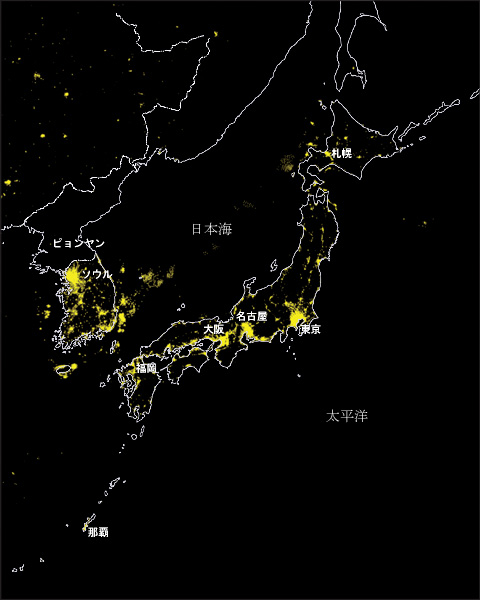
City lights distribution during night time seen from space
City lights distribution during night time around Japan can be seen by the
use of The Defence Meteorological Satellite Program(DMSP) Operational Linescan System(OLS) data.
DMSP satellite was launched by USA which has a sun synchronous near-polar orbit at an
altitude of approx. 830km above the surface of the earth and revolves around the earth in about 101minutes. The visible and infrared OLS sensors observe the global information such as distribution of clouds, cloud top temperatures, fires, upper atmospheric sources, city lights,etc., twice each day during day time and night time.
This image was made by the combination of some cloud free OLS night time scenes acquired in 2001 with map information, and the lights are displayed in yellow color. Bright yellow
areas of land are seen mostly in urban area, and a wide range distribution can be seen in a big city. On the other hand, dotted lights being in the Sea of Japan are considered to be bulb illuminations of fishing boats. In the Korean peninsura, it is very impressive that a big difference of city lights distribution which seems to be a difference of economic
activities between North and South Korea is detected on the 38th parallel as a boundary.

A night time image of DMSP around Japan (Data: DMSP OLS, November 2001)
(Data:NOAA NGDC)

